Sector 8 – DHA City Karachi
Sector 8 in DHA City Karachi is situated approximately 3.5 kilometers (2.3 miles) from the main Gate of DCK. It lies directly south of Sector 5 and east of Sector 7. The sector divides into four sub-sectors: 8A, 8B, 8C, and 8D and offers various options for residents and businesses. The sector includes different sized plots: 500 or 1000 square yard residential plots, and 200 square yard commercial plots.

Directions – Main Gate to Sector 8
To begin your journey to Sector 8 in DHA City, you enter through the main gate of DCK. You then proceed straight through the DHA Square roundabout. From there, you follow the DHA City Main Road for 1.2 kilometers. As you drive, you notice that the road curves slightly to the left; the CBD Commercial area starts on your right. You continue driving for another 1.6 kilometers on the Main Road. While you travel along the Main Road, you keep an eye out for two landmarks: the ‘Velochi Racing Circuit’ and a graveyard. Both of these appear on your left side. After you pass these landmarks, you drive for an additional 900 meters on the DHA City Main Road. At that point, you make a right turn onto 8th Main Street East. This street leads you directly into Sector 8. Sector 8 is located south of Sector 3 and Sector 5. It lies to the west of Sector 7.
Plots for Sale in Sector 8
| Sector | Plot Size (Marla) | Plot Size (Square Yards) | Price (Crore/Lakh PKR) | Price (Million PKR) |
|---|---|---|---|---|
| 8D | 20 | 500 | 1.25 – 1.4 Crore | 12.5 – 14 Million |
| 8C | 20 | 500 | 1.05 – 1.4 Crore | 10.5 – 14 Million |
| 8A | 40 | 1000 | 2.6 – 3.25 Crore | 26 – 32.5 Million |
| 8B | 80 | 2000 | 5.5 Crore | 55 Million |
*See the latest plot prices for Sector 8 here.
Price Distribution – Sector 8
Image Gallery – Sector 8


What You’ll Find in Sector 8
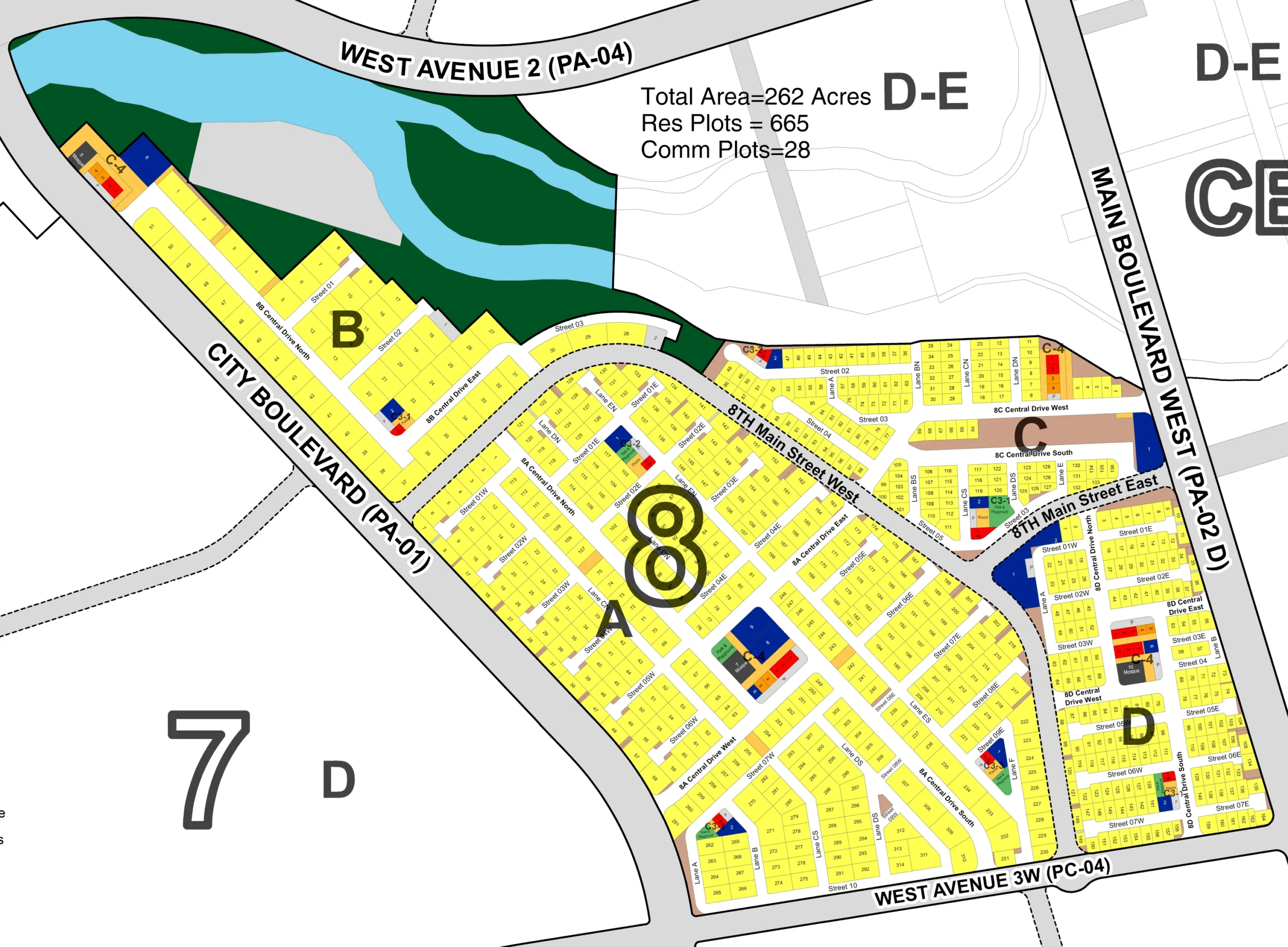
Plan Details and Statistics
The Map of Sector 8 includes the following statistics:
-
Total Area = 262 Acres
-
Residential Plots = 665
-
Commercial Plots = 28
Road Network and Boundaries
The map highlights the road network and boundaries of Sector 8:
-
WEST AVENUE 2 (PA – 04): Forms part of the northern boundary.
-
CITY BOULEVARD (PA – 01): Forms the western boundary.
-
WEST AVENUE 3W (PC – 04): Forms the southern boundary.
-
MAIN BOULEVARD WEST (PA – 02 D): Forms the eastern boundary.
-
8TH Main Street West: A significant internal road running north-south.
-
8TH Main Street East: A significant internal road running north-south.
Sub-sectors/Blocks
Sector 8 is divided into several labeled sub-sectors or blocks:
-
Block A
-
Block B
-
Block C
-
Block D
Adjacent areas are also labeled, providing context:
-
Sector 7 (D): Located to the south-west.
-
Block D-E: Located to the north and east.
-
Block C-4: Located to the north-west.
-
Block CE: Located to the east.
-
CBD: A large area labeled “CBD” (Central Business District) is located adjacent to the east.
Land Use Distribution
Based on the color coding (and consistent with the legend observed in similar maps):
-
Residential (Yellow): Residential plots are widely distributed across Blocks A, B, C, and D, forming the majority of the sector’s area, aligning with the “Res Plots = 665” statistic.
-
Commercial (Red): Commercial areas are strategically located, particularly along the main boulevards and some internal main streets, aligning with the “Comm Plots = 28” statistic.
-
Parks & Green Usages (Green): Green spaces and parks are integrated within the sector, contributing to the environment.
-
Nullah (Light Blue/Cyan): A natural watercourse is present along the northern boundary, influencing the layout and often accompanied by green areas.
-
Other Amenity (Grey/Various Blues): Areas for various amenities, institutions (like education/healthcare), utilities, or other special purposes are marked.